Science Behind the Scenes in Cape Town
A new interactive tool tracks the progress of water-saving activities that can help avoid the next “Day Zero”

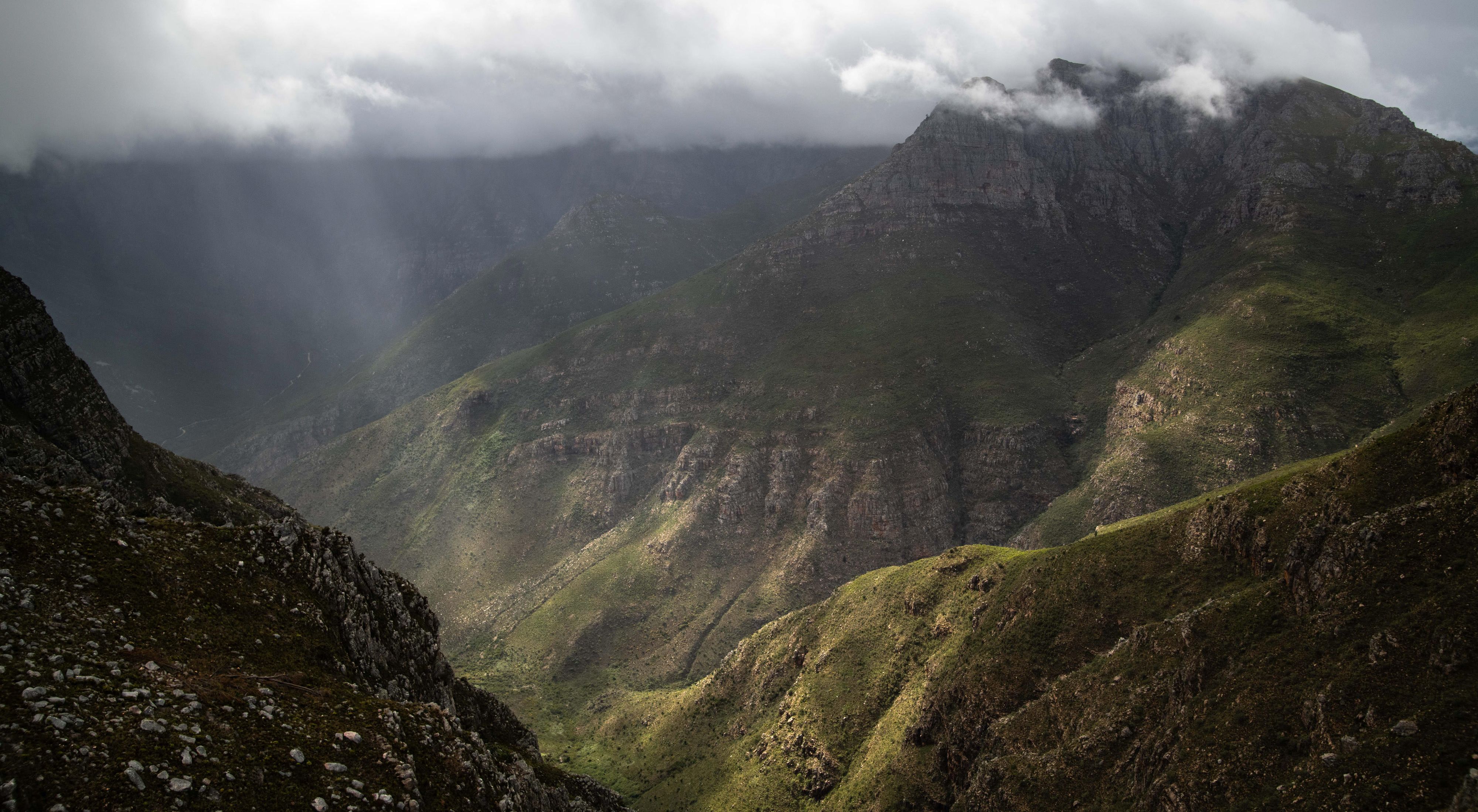
“It can take up to three hours of hiking to get to the furthest of our stream monitoring sites.
Du Toit’s Peak is often shrouded in early morning mist. We start early and hike through deep ravines, past spectacular rocky outcrops and up steep, pine-covered slopes. Fire is part of the cycle of life in this area, and we often have to use all fours to get through tangled, fire-scorched vegetation. By midday, the skies are usually blue and clear, but the sun can be fierce.
At times, the water in the streams is freezing cold. Occasionally, we need wade into rock-lined pools to download data and adjust equipment. Hiking home in wet gear is character building. It’s physically exhausting. But our days in the mountains are special.”
Richard Bugan’s hikes into the mountains outside Cape Town, South Africa, aren’t just for fun: He’s gathering stream flow information from hydrological monitoring equipment set up at six remote stream sites. This data can validate or invalidate the science that underpins the water benefits of the Greater Cape Town Water Fund’s (GCTWF) interventions. And so far, the results have been extremely encouraging.
In early 2018, Cape Town came dangerously close to reaching “day zero”—a term for the day that the taps would run dry in residential areas of the city. While that doomsday was postponed—due to strict water-use restrictions, cutting irrigation water to agriculture, and pumping in extra water—it is only a matter of time before another water crisis is on the horizon again.
But the GCTWF offers nature as a long-term solution, and is now currently focused on removing water-guzzling, invasive pine, gum and wattle tree species from 54,300 hectares (134,178 acres). This work has the added benefit of restoring habitat for native fynbos: Seventy percent of plants in the Cape Floral Region can be found nowhere else on Earth.
The project has a bold vision, requires detailed reporting and transparent scientific verification. To achieve this, the GCTWF partnership teams in South Africa needed a centralised management system to track field operations by multiple stakeholder organisations, allocate funding and to report on the resultant water reclamation benefits calculated through monitoring and evaluation.
Bugan, a hydrogeologist on TNC’s South Africa team, explains how they solved this complex challenge with a new Decision Support System (DSS) tool.

nature.org: What is the DSS tool? How does it help you?
Bugan: The Decision Support System (DSS) is an interactive online dashboard that tracks the progress of all activities undertaken by the partners of the Water Fund. It is designed to be flexible, transparent, and user-friendly.
At a broad level, this tool has been designed to track implementation progress against our planned targets in the long-term. On the ground, it allows us to better coordinate in-field activities, so that we can constantly improve and update our implementation efficiencies and methods.
At its most exciting, it is a tool that presents the latest stream flow data from our experimental catchments, and shows you how much water we are restoring to the system. To this end, it is an interactive map that follows the monthly progress of our in-field teams who are reclaiming water for Cape Town, which is very cool.

nature.org: What made you design the system? Why did you need it?
Bugan: It all goes back to a 54-page report, first released in 2018, by an extraordinary team from TNC that worked in collaboration with top scientists―environmentalists, hydrologists and invasion biologists―in the Western Cape.
Published as the Business Case for the Greater Cape Town Water Fund, the report showed how “green” ecological infrastructure restoration would cost 5 to 12 times less than “grey” infrastructure (e.g., desalinising ocean water, drilling for groundwater, building dams), and could reclaim more water per year for Cape Town.
This nature-based “green” solution recommended the removal of water-guzzling invasive alien plant species such as pine, gum, and wattle from 54,300 hectares in seven rugged mountain catchments, located to the east of, and upstream from, four reservoirs serving the Greater Cape Town area.
The business case proved how our actions would yield annual water gains of 55 billion litres per year—or two months water supply for Cape Town—during the first six years of the project. By 2045, our actions would yield 100 billion litres of water per year, equivalent to one-third of Cape Town’s current annual supply.
The project proposal was bold, visionary, and enormously complex.
The TNC project team gathered funding, organized a steering committee, convened working groups, and then set out in 2019 to clear invasive alien species across 54,300 hectares in seven targeted catchments in the Cape Mountains.
Today, we manage a program that involves hundreds of people, multiple government departments, private sector funders, foundations, property owners, wildfire organizations, and conservancies—all using the DSS tool.


nature.org: What makes the DSS tool work?
Bugan: The DSS tool is the online interactive nerve center of the GCTWF. Broadly speaking, it has two main components.
The first component is operational. This involves the coordination of multiple layers of information, or data sets, that reflect the monthly field work taking place in each of the 87 Hydrological Management Units (HMUs) which crisscross the 54,300 hectares targeted for clearing.
The HMUs have different funders, different organisations managing teams on the ground, varying challenges, and different costs of operation. For example, we have areas where specially trained, high-angle teams need to be helicoptered into rugged mountain terrain, for 14 days at a time, to clear invasive pine species. High-altitude clearing is far more expensive than clearing a lowland wetland.
At the end of each month, we input thousands of pieces of information―delivered individually or by our stakeholders in standardized monthly reporting template spreadsheets―into our magic DSS tool. All the information is crunched and provides everyone with an updated online dashboard. Everyone can see the exact progress of the project at all times.
Secondly, the DSS dashboard reflects regular updates from my paired catchment experiments. This requires my colleagues and I to hike into the mountains to download flow information from hydrological equipment set up at six remote stream sites. The flow of water is monitored with electronic data loggers.

nature.org: The project is on its way. Can your magic box—the DSS tool—be used elsewhere in the world?
Bugan: Absolutely yes. The DSS tool links projected plans to captured data from field workers and data collection teams, and allows us to constantly track and improve what we are doing. So far, the science verifies that what we are doing, really works. This is important for transparency, planning, and sustainability.
The DSS also contains the start dates of field implementation activities, cost per hectare to remove invasive plants, management effectiveness in various HMUs, and even socio-economic impacts. For example, we are working toward creating 350 green jobs. This tool shows how many women and youth are included in the teams and on which sites they are working.
Our DSS tool is online, for all to see, in almost real time. It offers a transparent project management tool that showcases evolving data for stakeholders and tracks the progress of the project visually.
The TNC team worked really hard to develop our innovative DSS tool box. And I believe, that it offers an operations blueprint for many other water fund projects around the world.